
Photo on Web offers view of sub propeller
Navy Times
By Andrew Scutro - Staff writer
Posted : Wednesday Aug 8, 2007 8:36:26 EDT
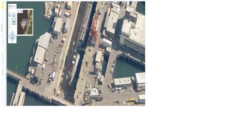
A photograph of a sensitive piece of Navy technology — the propeller of a ballistic-missile submarine — now appears on the Internet, thanks to commercial efforts to photograph and map all corners of the Earth by aircraft and satellite.
The Navy goes to great lengths to conceal the design of its submarine propellers, but the aerial photo now on the Internet clearly shows the blades. A wider view of the photo shows a second Ohio-class submarine in the water nearby.
Brought to the public eye via a blog, the photograph from Microsoft’s “Virtual Earth†site shows an Ohio-class submarine in dry dock in broad daylight with no shroud over the propeller.
While he confirmed that the photo shows an Ohio-class hull, Lt. Cmdr. Chris Loundermon, submarine force public affairs officer, said it’s unclear what submarines are pictured in the photos.
“Yes, that is an Ohio-class submarine, either an SSBN or SSGN, in dry dock in the Pacific Northwest at the intermediate maintenance facility on the Naval Submarine Base Kitsap-Bangor,†he said.
Though the photograph appears on a Microsoft site, photo credit is given to Pictometry International Corporation, which specializes in such aerial photography. Several messages left for a company spokesman were not returned Tuesday.
Pictometry’s motto is, “See anywhere, measure anything, plan everything,†according to its Web site.
The submarine maintenance facility is photographed from several angles.
Microsoft provided a statement attributed to Justin Osmer, a senior product manager at LiveSearch, through its public relations company, Waggener-Edstrom.
“Our mapping products fully comply with U.S. laws governing the acquisition and publishing of aerial imagery,†according to the statement. “The clarity of the images is impressive, but beyond a certain zoom level the images become ‘pixilated’ and blur. In addition some Virtual Earth imagery can only be viewed from certain distances.
“Additionally, there are other instances where images have been intentionally blurred for security purposes. We review requests to do so on a case-by-case basis. In addition, we do not provide real-time data or live satellite images. All the imagery has been collected at a fixed point in time over a period of the last few years.â€
Naval Sea Systems Command had not responded to a request for information about government rules on overflights of naval shipyards and repair facilities by Tuesday evening.
Navy Times
By Andrew Scutro - Staff writer
Posted : Wednesday Aug 8, 2007 8:36:26 EDT
A photograph of a sensitive piece of Navy technology — the propeller of a ballistic-missile submarine — now appears on the Internet, thanks to commercial efforts to photograph and map all corners of the Earth by aircraft and satellite.
The Navy goes to great lengths to conceal the design of its submarine propellers, but the aerial photo now on the Internet clearly shows the blades. A wider view of the photo shows a second Ohio-class submarine in the water nearby.
Brought to the public eye via a blog, the photograph from Microsoft’s “Virtual Earth†site shows an Ohio-class submarine in dry dock in broad daylight with no shroud over the propeller.
While he confirmed that the photo shows an Ohio-class hull, Lt. Cmdr. Chris Loundermon, submarine force public affairs officer, said it’s unclear what submarines are pictured in the photos.
“Yes, that is an Ohio-class submarine, either an SSBN or SSGN, in dry dock in the Pacific Northwest at the intermediate maintenance facility on the Naval Submarine Base Kitsap-Bangor,†he said.
Though the photograph appears on a Microsoft site, photo credit is given to Pictometry International Corporation, which specializes in such aerial photography. Several messages left for a company spokesman were not returned Tuesday.
Pictometry’s motto is, “See anywhere, measure anything, plan everything,†according to its Web site.
The submarine maintenance facility is photographed from several angles.
Microsoft provided a statement attributed to Justin Osmer, a senior product manager at LiveSearch, through its public relations company, Waggener-Edstrom.
“Our mapping products fully comply with U.S. laws governing the acquisition and publishing of aerial imagery,†according to the statement. “The clarity of the images is impressive, but beyond a certain zoom level the images become ‘pixilated’ and blur. In addition some Virtual Earth imagery can only be viewed from certain distances.
“Additionally, there are other instances where images have been intentionally blurred for security purposes. We review requests to do so on a case-by-case basis. In addition, we do not provide real-time data or live satellite images. All the imagery has been collected at a fixed point in time over a period of the last few years.â€
Naval Sea Systems Command had not responded to a request for information about government rules on overflights of naval shipyards and repair facilities by Tuesday evening.

Comment